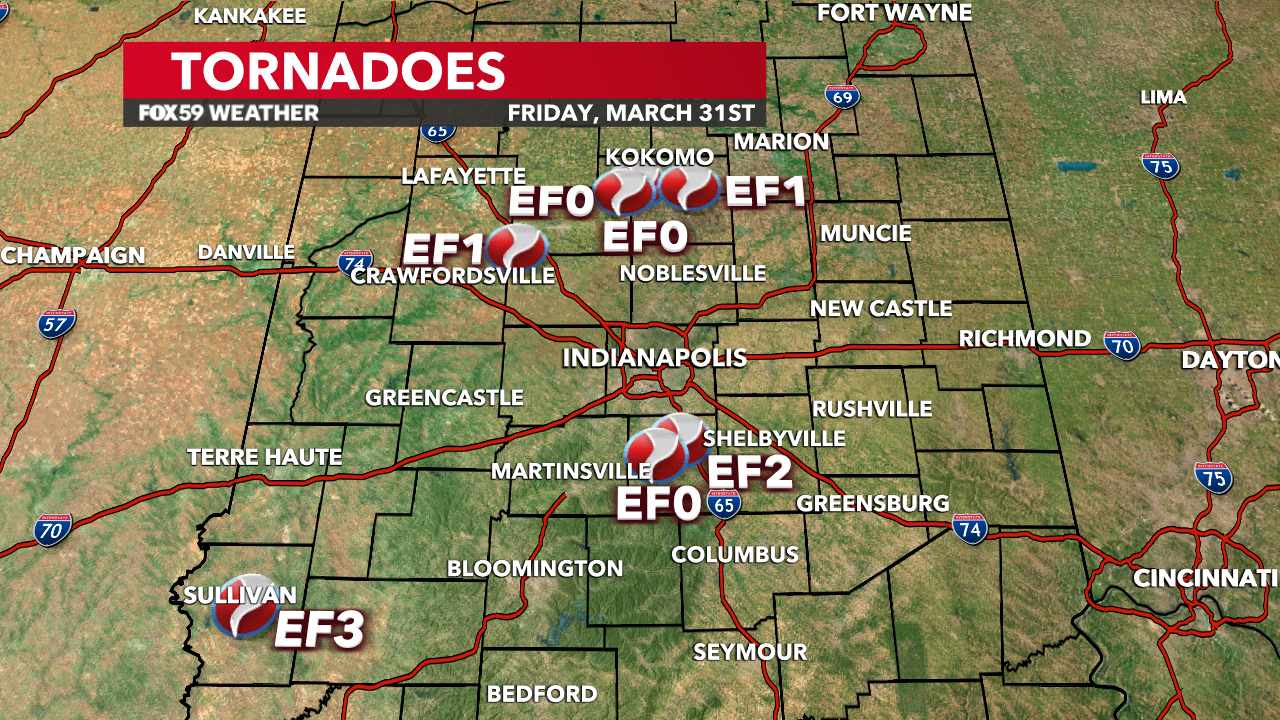
Seven tornadoes confirmed following Friday night’s storms
INDIANAPOLIS – Severe weather and strong tornadoes tore across the Midwest, including Indiana.
Here’s a preliminary review of the available data so far from the National Weather Service Indianapolis office.

Tornado – Sullivan, Sullivan County
| Date | 03/31/2023 |
| Time (Local) | 10:21 PM EDT |
| EF Rating | Preliminary EF-3 |
| Est. Peak Winds | 155 mph |
| Path Length | 8.94 miles |
| Max Width | TBD |
| Injuries / Deaths | 3 fatalities |
More information will be added to this tornado report.
Tornado – Bargersville, Johnson County
| Date | 03/31/2023 |
| Time (Local) | 11:27 PM EDT |
| EF Rating | EF-0 |
| Est. Peak Winds | 85 mph |
| Path Length | 1.93 miles |
| Max Width | 25 yards |
| Injuries / Deaths | 0/0 |
NWS Summary: Sporadic tree damage was noted in the town of Providence, IN which were mainly straight line winds. The tornado began to form to the N/NE of Providence where slightly more intense tree damage was noted. The tornado continued to move E/NE and crossed State Road 135 between W Rd 100 N and W Rd 200 N. Multiple power lines were damaged and laying across 135. Metal roofing of a barn just east of 135 was peeled back suggesting winds upwards of 85 mph. The tornado continued moving E/NE towards IN-144 but lifted just before reaching IN-144. Sporadic tree damage was noted to the south of IN-144.
Tornado – Whiteland, Johnson County
| Date | 03/31/2023 |
| Time (Local) | 11:33 PM EDT |
| EF Rating | Preliminary EF-2 |
| Est. Peak Winds | 135 mph |
| Path Length | 3.54 miles |
| Max Width | 316 yards |
| Injuries / Deaths | 0/0 |
NWS Summary: The storm continued moving northeast and a tornado redeveloped in an open field just to the west of the Park Forest neighborhood. The tornado moved through the neighborhood where EF-0 to EF-1 damage was noted initially. The tornado intensified as it moved through the neighborhood and produced low-end EF2 damage. A cell tower near Whiteland Sewer Department just to the NE of the neighborhood sustained damage as the tornado continued moving northeast towards US Hwy 31. Once the tornado crossed Hwy 31 it moved through a neighborhood near Briar hill Dr. High end EF-1 to mid range EF-2 damage occurred from Pineadale Dr to Forum st. The tornado continued to strengthen as it moved northeast, producing mid range EF-2 damage near Forum Dr. Multiple homes sustained major roof damage. A few homes had most exterior walls collapse and one poorly constructed home had only one wall left standing. High end EF-2 damage was observed as it crossed the railroad track and hit a neighborhood near Paris Ln and E Pearl St. Numerous homes sustained roof damage. A poorly constructed home along E Pearl St was completely destroyed with only a concrete slab left. This home was very poorly anchored and could explain the compete removal of the home. The tornado produced damage to a home along Whiteland Rd before crossing an open field. It maintained intensity before hitting a few more homes along Graham Rd. Many trees were uprooted or snapped with significant roof damage and a collapsed garage. A
warehouse further northeast along Graham Dr. sustained preliminary high end EF-2 damage. Portions of the warehouse were completely gone and blown onto I-65. The tornado quickly lifted just east of I-65.
Tornado – Colfax, Clinton County
| Date | 03/31/2023 |
| Time (Local) | |
| EF Rating | EF-1 |
| Est. Peak Winds | 110 mph |
| Path Length | |
| Max Width | |
| Injuries / Deaths |
Tornado – SW Howard County
| Date | 03/31/2023 |
| Time (Local) | |
| EF Rating | EF-0 |
| Est. Peak Winds | 80 mph |
| Path Length | |
| Max Width | |
| Injuries / Deaths |
Tornado – SW Howard County
| Date | 03/31/2023 |
| Time (Local) | |
| EF Rating | EF-0 |
| Est. Peak Winds | 80 mph |
| Path Length | |
| Max Width | |
| Injuries / Deaths |
Tornado – Eastern Howard County
| Date | 03/31/2023 |
| Time (Local) | |
| EF Rating | EF-1 |
| Est. Peak Winds | 110 mph |
| Path Length | |
| Max Width | |
| Injuries / Deaths |

Comments are closed.